Gradation of Rocks: UIAA Scale and Bengal's Climbing Faces
Gautam DuttaCategory: Article
Date of Publication: Jun 17 , 2026
These days we often hear the name UIAA, which was not so common even a few years ago. Our Indian Mountaineering Foundation (IMF), officially got registered in 1961. Although the IMF has been an affiliated member of UIAA almost since its inception and regularly renews its association, two possible reasons may explain the recent prominence:
- On 28 November 2017, at the India Habitat Centre in New Delhi, during one of India’s major industry conferences organized by The Confederation of Indian Industry (CII), a seminar titled “Unveiling Opportunities in Adventure Tourism” featured a successful presentation by Wg. Cdr. Amit Chowdhury (Rtrd), then newly elected President of the UIAA Safety Commission, on “Safety in Adventure Activities and the Role of UIAA.”
- In 2018, IMF made special mention of its communication with UIAA while promoting its Mountaineering Festival, which further highlighted the connection.
During 2018–2019, IMF organized Mountaineering Festivals at four locations in the Indian Himalayas—Himachal Pradesh (23 July to 12 August 2018), Sikkim (15 October to 3 November 2018), Uttarakhand (20 May to 8 June 2019), and Ladakh (22 July to 11 August 2019). These festivals offered international climbers thrilling challenges at very economical promotional prices. The aim was to ensure easier access for mountaineers and trekkers from across the globe to the Indian Himalayas. At the same time, with the direct involvement of UIAA, the festival sought to help Indian climbers enhance their skills and deepen their knowledge of safety practices.
Union Internationale des Associations d’Alpinisme(UIAA), aka International Climbing and Mountaineering Federation, is the international forum for formulating principles, ethics, guidelines, structure etc. for Climbing and Mountaineering overall. Formally established in Chamonix, France on 27th August 1932, when 20 mountaineering associations met for an alpine congress(3rd), felt the need to found an international federation to “study and solution of all problems regarding mountaineering”. Count Charles Egmond d’Arcis from Switzerland became the first President, and he gave the new federation the name UIAA. It finally resolved the UIAA Climbing Grades in 1967, 35years later. As of the 2025 General Assembly, it represents 99 member organizations (associations and federations) from 77 countries, including India, from six continents. These 99 organizations are comprised of 74 full members, one unit member, 18 associate members, and balance observer members. Europe is the largest continental body with 58 members from 40 countries. Presently, the UIAA is actively expanding in Central and South America. It is now a Swiss-based organization with its office at Bern, Switzerland, focusing on safety standards, mountain protection, training and the development of the sport. It has been recognized by the International Olympic Committee (IOC) since 1995. Present president is Peter Muir and General Secretary Wg. Cdr. Amit Chowdhury (Rtrd).
Climbing routes are graded to show how hard and risky they are. The first climber suggests a grade, but it’s usually refined by later ascents. While many countries created their own systems, a few have become dominant worldwide, leading to standardization. Grades have steadily been risen, thanks to better techniques and equipment.
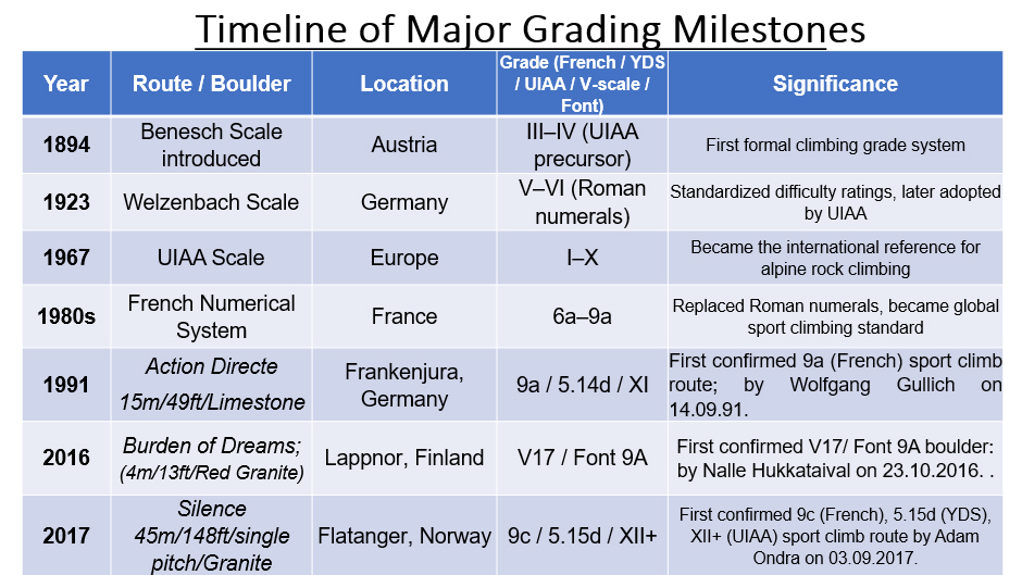
For understanding history of grading in brief, we may proceed as follows:
Early Systems
- 1894 – Benesch scale (Austria): First grading system, levels VII (easy) to I (hard). Later added 0 and 00.
- 1923 – Welzenbach scale (Germany): Reversed Benesch i.e. levels I (easy) to VII (hard) , became popular in the Alps.
- 1967 – UIAA scale: Adopted Welzenbach, used Roman numerals I–VI with +/− refinements. Later expanded to VII and beyond, now stands at XII+.
Major Modern Systems
- British E grade: 1920s – Britain (Gritstone Era) climbers on short, bold gritstone routes needed a system that captured both technical moves and seriousness. Hence the two parts – adjectival grade (overall seriousness, e.g., E1, E2…) and technical grade (hardest move, e.g., 6a). Complex but tailored for traditional climbing, and yet remain unique for trad climbing.
- UIAA scale: 1930s – Germany (UIAA Alpine Tradition) Alpine climbing demanded a simple, linear scale. Finally, the UIAA Roman numerals(I–XII) with +/− was born, focusing on the hardest technical section. Popular in Germany, Austria, Switzerland, and Central Europe. UIAA is still the alpine benchmark.
- 1950s – Italy (Dolomites & Hybrid Use) Italians adopted UIAA grades for alpine routes in the Dolomites, but later embraced French decimal grades for sport climbing crags. This duality reflects their mixed climbing culture.
- American YDS (1950s): American Yosemite Decimal System (YDS) uses “5.x” format (e.g., 5.10a). Dominant in North America. Adds suffixes for risk: PG (pretty good or safe), R (risky), X (very dangerous).
- French numerical scale (1980s): Uses numbers (1–9) with letters a, b, c and +. Became dominant in Europe, along with Sport Climbing Revolution with bolts and indoor walls; the decimal system (5a–9c), now the global standard for sport climbing. It measures pure technical difficulty, ignoring danger.
- Ewbank system (Australia/NZ/South Africa): Numbers only, open ended, considers both technical difficulty and risk.
- Saxon scale (Germany/Switzerland): Roman numerals with a/b/c refinements. Includes psychological and risk factors.
- Scandinavian scales: Similar to UIAA but open ended with +/− refinements.
- Brazilian scale: Mix of Roman numerals (up to VI sup.) and Arabic numbers (7a, 7b…).
- Polish Cracow scale: Extends UIAA beyond VI+ with VI.1, VI.2, etc.
Free Climbing Highlights
- 01) A milestone came in 1991 when Wolfgang Güllich climbed Action Directe, rated 9a (French), 5.14d (YDS), XI (UIAA). It was the first confirmed 9a (French) sport climb route at Frankenjura, Germany.
- 02) the second milestone came in 2017 when Adam Ondra climbed Silence in Norway – graded 9c (French), 5.15d (YDS), XII+ (UIAA). Still unrepeated. The hardest sport climb route yet now.
- May please note that in free climbing, the main systems are French sport grades (e.g., 7c+), American YDS (e.g., 5.13a), and the UIAA scale (e.g., IX+). These measure technical difficulty, while the American system adds R/X for risk. Britain uses the E‑grade (e.g., E4 6a).
Bouldering
- Bouldering uses the American V(Hueco)‑scale (e.g., V14) and the French Font (Fontainebleau) system (e.g., 8C+), often marked with “F” to avoid confusion with sport grades. Sport routes sometimes describe their hardest moves using boulder grades (e.g., f7a with a V6 crux).
- Hardest boulder so far is the Burden of Dreams in Lappnor, Finland –first climbed by Nalle Hukkataival in 2016 - V17/Font 9A. It is the first confirmed V17/Font 9A boulder, though repeated about four times so far (2025) by others.
- Other systems: Japanese Dankyū (martial arts style), John Gill’s “B” system, British Peak B grades.
Aid Climbing
- Original A grades (A0–A5): Based on gear placements.
- New wave A grades (1990s): Expanded to A6, added + refinements from A2.
- C grades: “Clean” aid climbing without hammer use.
Ice & Mixed Climbing
- WI grades (Water Ice): WI1–WI13. Focus on technical challenge.
- AI grades (Alpine Ice): For year-round firmer ice.
- M grades (Mixed climbing): For rock + ice routes, up to M16.
- D grades: For pure dry tooling (rock only) in Scottish Winter.
Mountaineering combines multiple grades to capture rock, ice, and mixed challenges. The International French Adjectival System (IFAS, e.g., TD+) matches the UIAA overall scale (I–VI). For example, the 1938 Heckmair Route on the Eiger is graded ED2 (IFAS), VI− (UIAA), A0 (aid), WI4 (ice), with a 60° slope. Commitment grades like the American National Climbing Classification System (I–VI) also apply.
In short, climbing grades evolved from simple Roman numerals to many systems worldwide. Today, the French numerical scale and American YDS dominate sport climbing, while beside UIAA, specialized systems (British E grades, Ewbank, Saxon, WI/M/D grades) handle traditional, alpine, and ice/mixed climbing. I will not get into further details, as these much traces of the evolution of overall grades are enough to help understand evolution of rock-climbing grading systems from history, especially across Britain, Germany (UIAA), Italy, France, and North America.
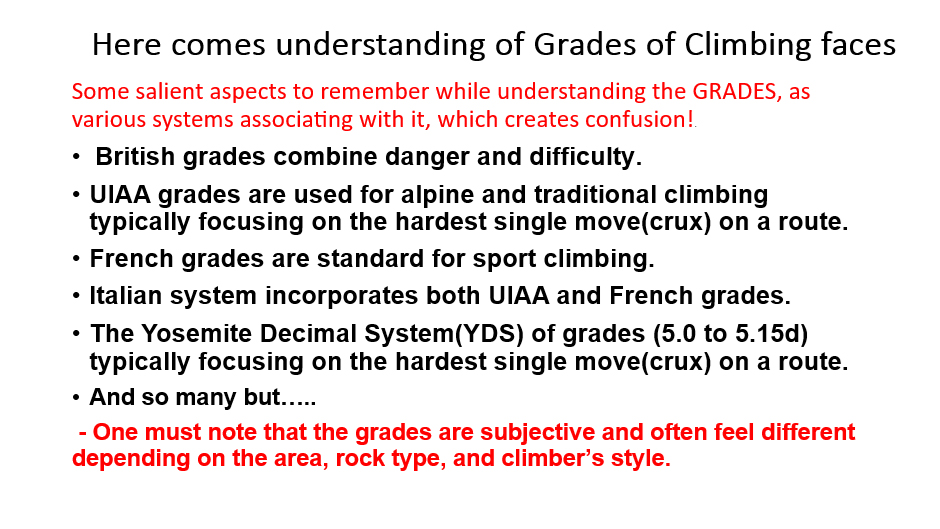
However, one thing is clear that, it will be very cumbersome if one mix-up various grade-scales in selecting the grade of routes for our rock-sites in Bengal. We must stick to one. Since the onset of rock climbing in our state(rather our country) during 1960s, we were not very sincere(rather, it was never a requirement) in the subject of Grade and didn’t keep it in the syllabi, except for Advance Rock-climbing Courses where we discussed the British adjectival system only, namely, easy(E), moderate(M), difficult(D), mild very difficult(MVD), very difficult(VD), hard very difficult(HVD), mild severe(MS), severe(S), hard severe(HS), mild very severe(MVS), very severe(VS) and hard very severe(HVS). But, by now we are aware that the UIAA grading system for rock climbing uses Roman numerals (I–XII, with + or – modifiers) to describe technical difficulty, ranging from very easy scrambles (I) to extreme climbs (XI–XII). The UIAA scale is widely used in Europe and internationally. Also, our country being affiliated with UIAA, we must follow the system in our case. It measures the hardest technical move on a route, not the overall endurance.
Also, to be very frank, my twofold intensions in this write-up are very clear:
1) elaborating different UIAA grades in its most simplified form so that anyone can assess a climb in terms of UIAA grading system, and
2) all the climbers must develop an inherent thought process and skill in assessing difficulties in climbing any face in the light of UIAA grading system. Please carry on the process from now on. Certainly, I will elaborate the overall condition of different rock-sites of West Bengal under the light of UIAA gradation system but for a specific climb, determination of correct grade is a task of yours.
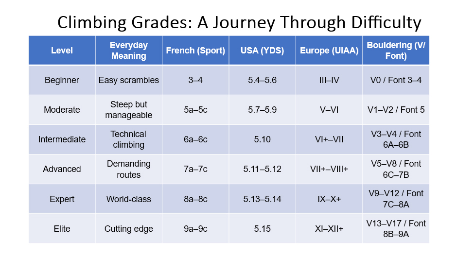
The UIAA Rock Climbing Grades – A Global Standard
The UIAA scale is one of the oldest and now most widely accepted grading systems in the climbing world. Originating in Europe, it was designed to provide a universal measure of technical difficulty. Importantly, as mentioned before, the UIAA grade reflects the hardest single move or sequence on a route, not the overall endurance or length of the climb. This makes it a precise tool for comparing climbs across different sites and regions.
Expanded Grade Descriptions
| UIAA Grade | Typical Features | Recognition on Natural Faces | Climber's Experience | Example for your easy assessment from the climbs of Susunia hill (it being known to many) |
|---|---|---|---|---|
| I-II | Easy scrambling | Gentle slopes, large ledges, walkable inclines | Feels like steep hiking; hands used occasionally for balance. | The last slope, while reaching the base of Angkami face. |
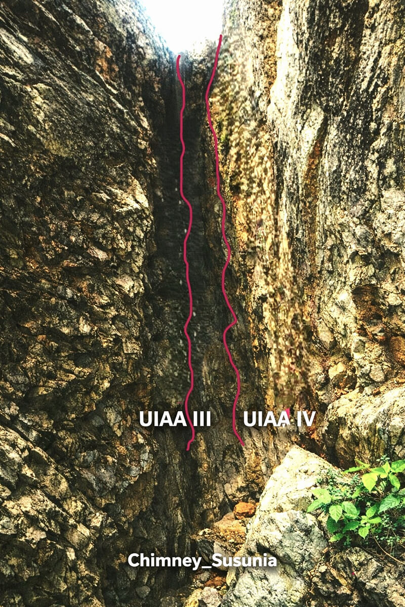
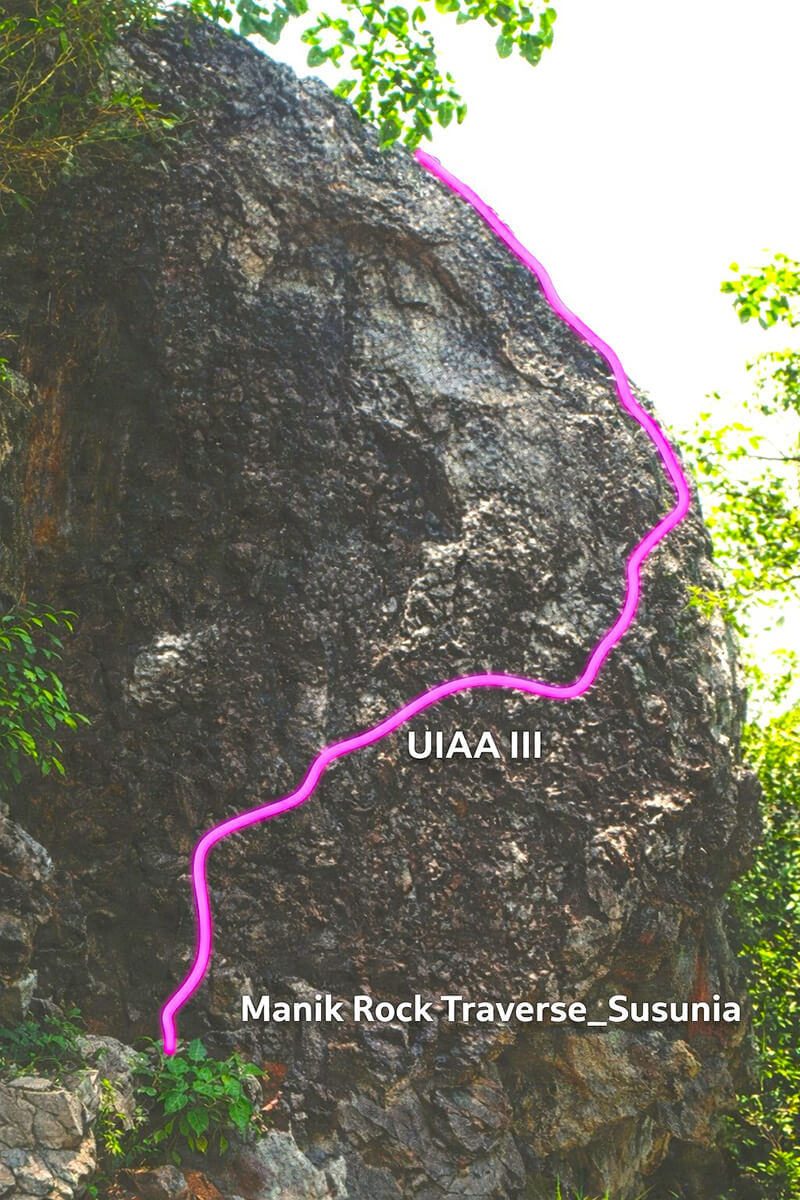
| III | Moderate climbing | Small steps, cracks, requires use of hands | First "true" climbing; rope protection advisable; beginners start here | 01. Staircase (Middle). 02. Chimney (inner route). 03. Manik Rock Traverse. 04. Chorda Rock (UIAA III+) |
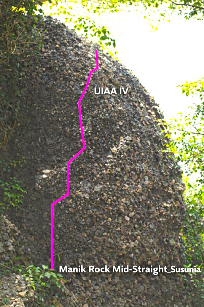
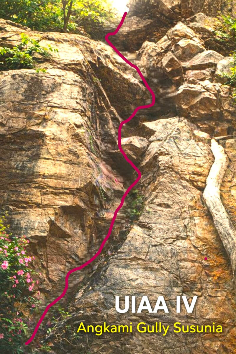
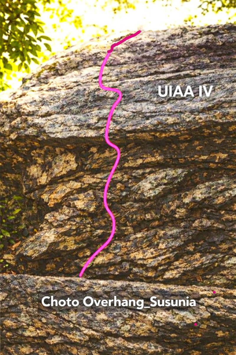
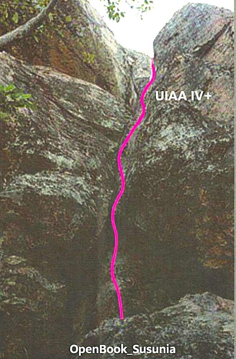
| IV | Difficult | Vertical sections, obvious holds, balance needed | Requires deliberate technique; exposure increases; climbers feel the seriousness of height. | 01. Manik Rock mid-Straight. 02. Angkami Gully. 03. Chimney (outer route). 04. Choto Overhang opposite Shakuni. 05. Staircase left route. 06.OpenBook(UIAA IV+) |
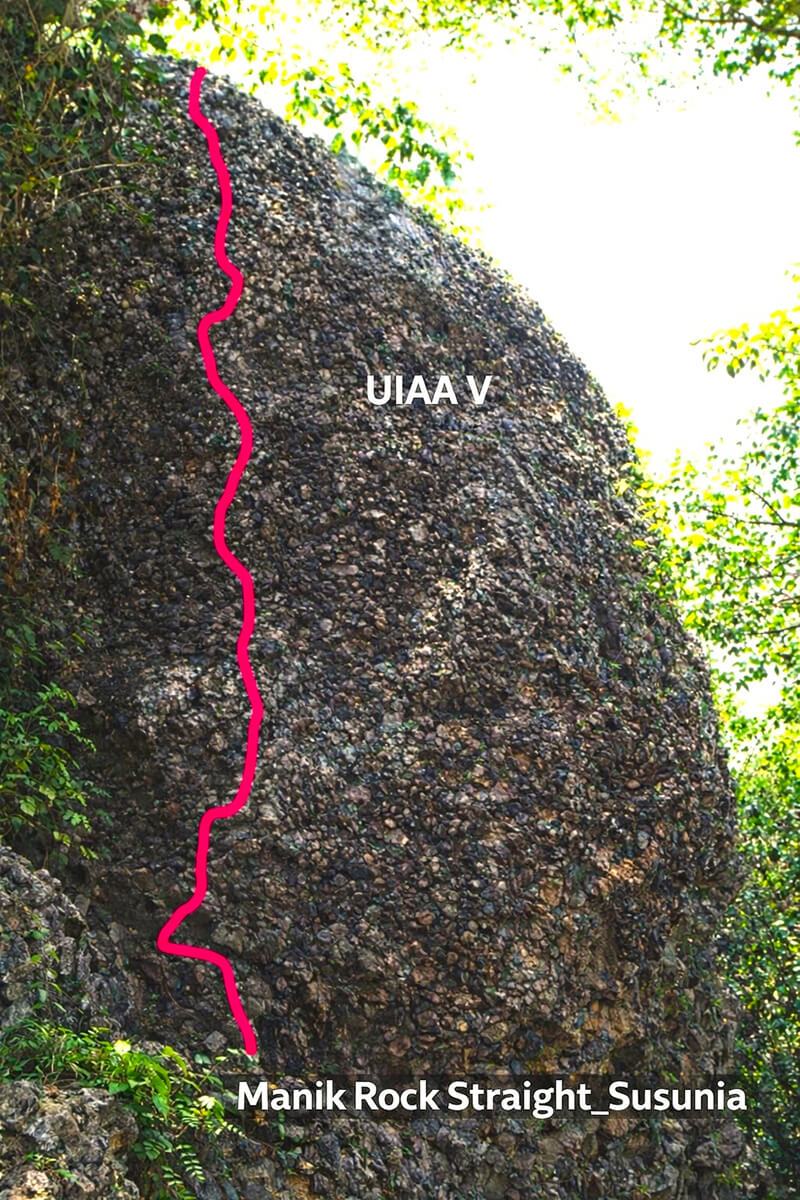
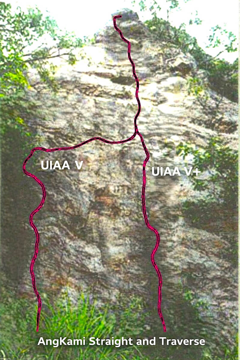
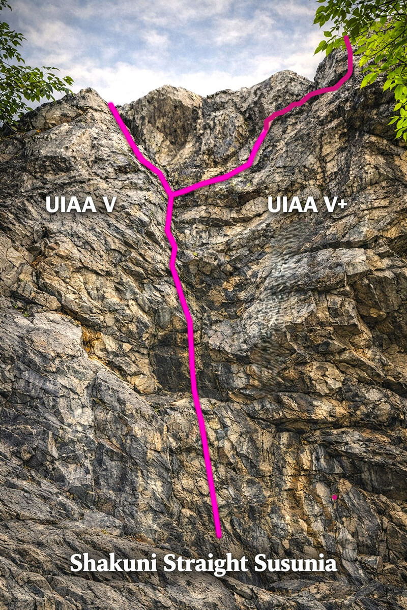
| V | Very difficult | Thin cracks, small holds, exposure increases. | Sustained technical moves; finger strength and precise footwork essential. | 01. Manik Rock Straight (left side route). 02. Shakuni Straight via left. 03. Angkami Straight face- traverse. 04. Kanjiman (Swing) Face, just on the left of Chimney entrance. 05. Angkami Straight face-direct (UIAA V+). 06. Shakuni Straight via right (UIAA V+). |
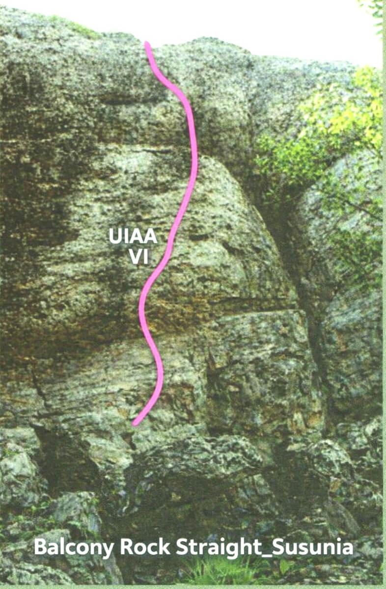
| VI | Extremely difficult | Steep faces, overhangs, technical sequences | Demands advanced skill, endurance, and rope systems. | Balcony Face (on the right side of Chimney entrance) |
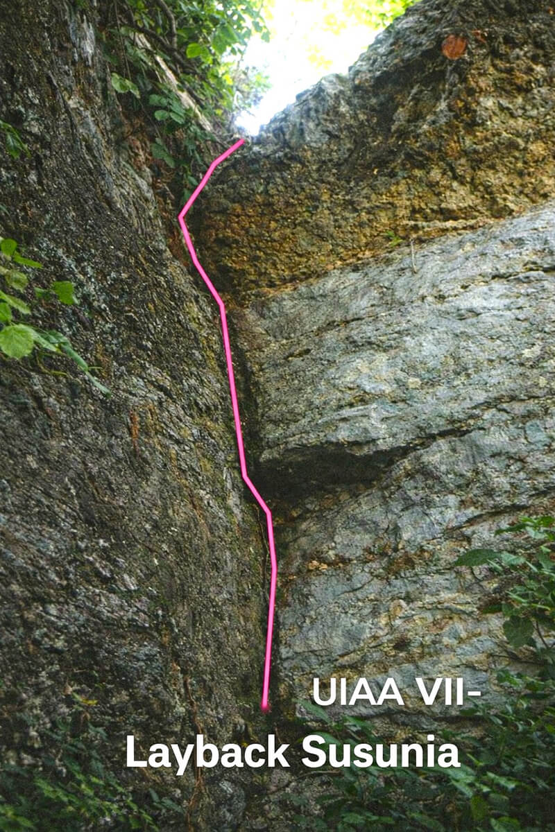
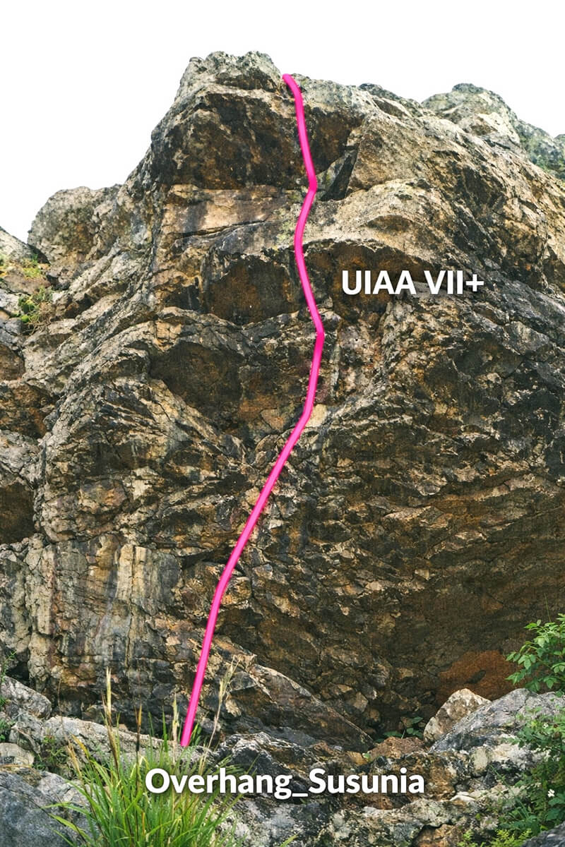
| VII | Elite/expert | Sustained vertical/overhanging climbing with tiny holds; gymnastic moves begin. | Demands very advanced skill, endurance, and rope systems; often the limit for traditional natural faces in Bengal. | 01. Layback (UIAA VII-; on the left trail of Staircase, behind it), 02. Overhang (UIAA VII+; at the starting phase of the overhanging rock beside Shakuni). |
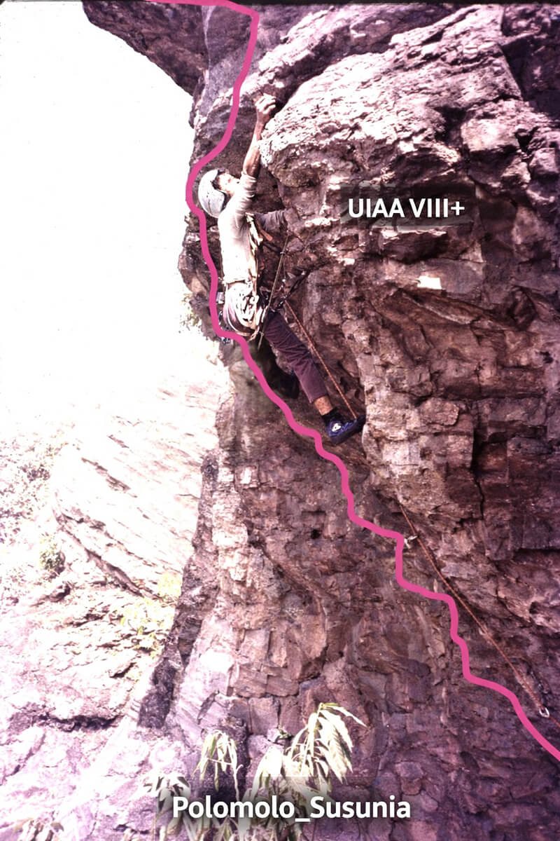
| VIII | -Do- | Steep roofs and overhangs; explosive power and memorized sequences required. | Rare outdoors in Bankura and Purulia; usually seen in international sport climbing arenas; requires exceptional strength and training. | Polomolo (UIAA VIII+) ...along the central crack line of the overhanging rock beside Shakuni). |
| IX | -Do- | Extremely technical; dynamic moves, micro edges, blank looking faces | -Do- | Not available at Susunia |
| X | -Do- | Sustained roofs and gymnastic sequences; microscopic holds, sparse protection. | -Do- | -Do- |
| XI | -Do- | Routes at the limit of human ability; extraordinary strength and precision. | -Do- | -Do- |
| XII | -Do- | The absolute pinnacle; imperceptible holds, movements resembling gymnastics on vertical stone. | -Do- | -Do- |

.jpg)
How Climbers Recognize Grades on Natural Faces
- Rock angle: Slabs (gentle) → lower grades; vertical or overhanging → higher grades.
- Hold size and distribution: Large ledges and cracks → easier; small crimps and thin cracks → harder.
- Exposure: Routes with long drops or sheer faces feel more difficult, even if technically moderate.
- Movement style: Friction climbing (slabs) often feels easier but requires balance; crack climbing demands technique; overhangs require power.
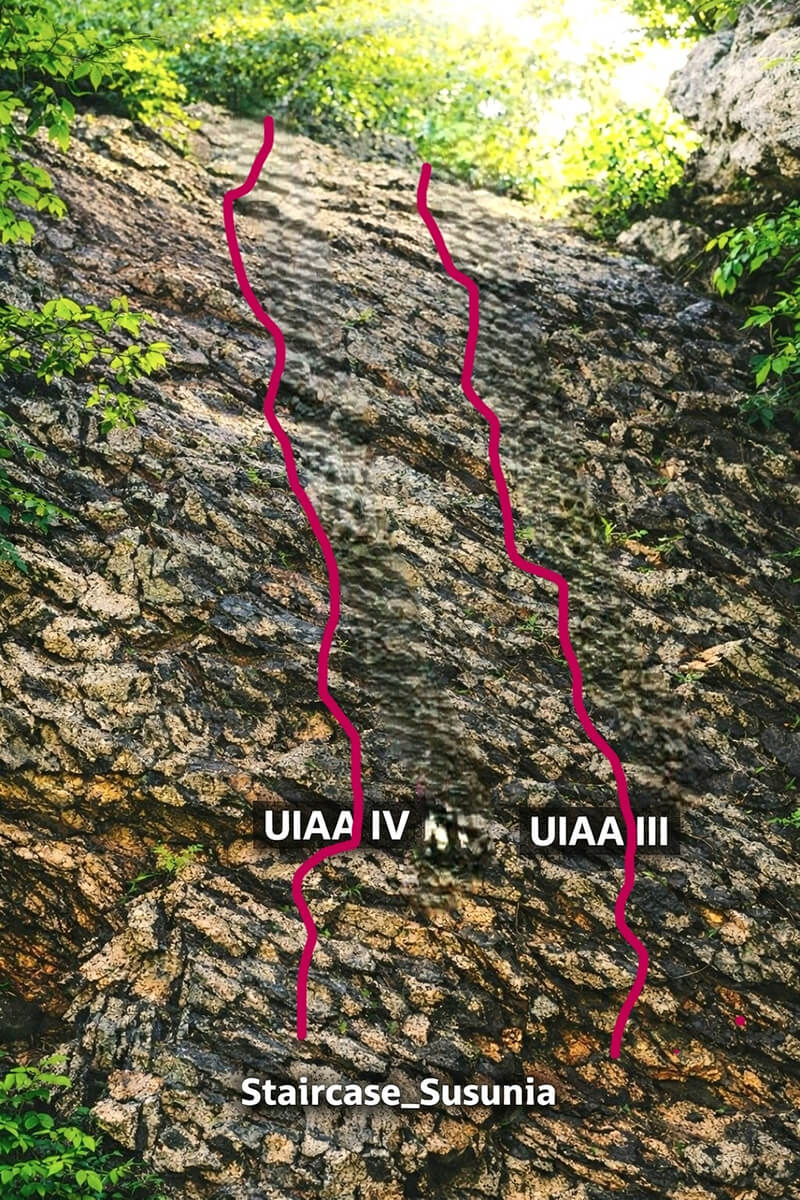
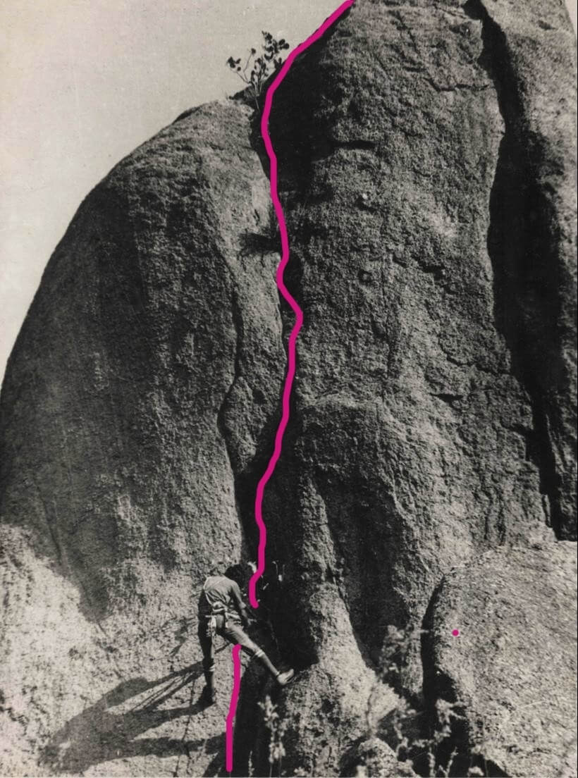
While elaborating the UIAA grades, I have tried describing a climber’s experience for each grade along with physical examples (with grade and route-marked photos of the climbs of Susunia hill) for your easy assessment of the grades. Hope this will help you a lot!
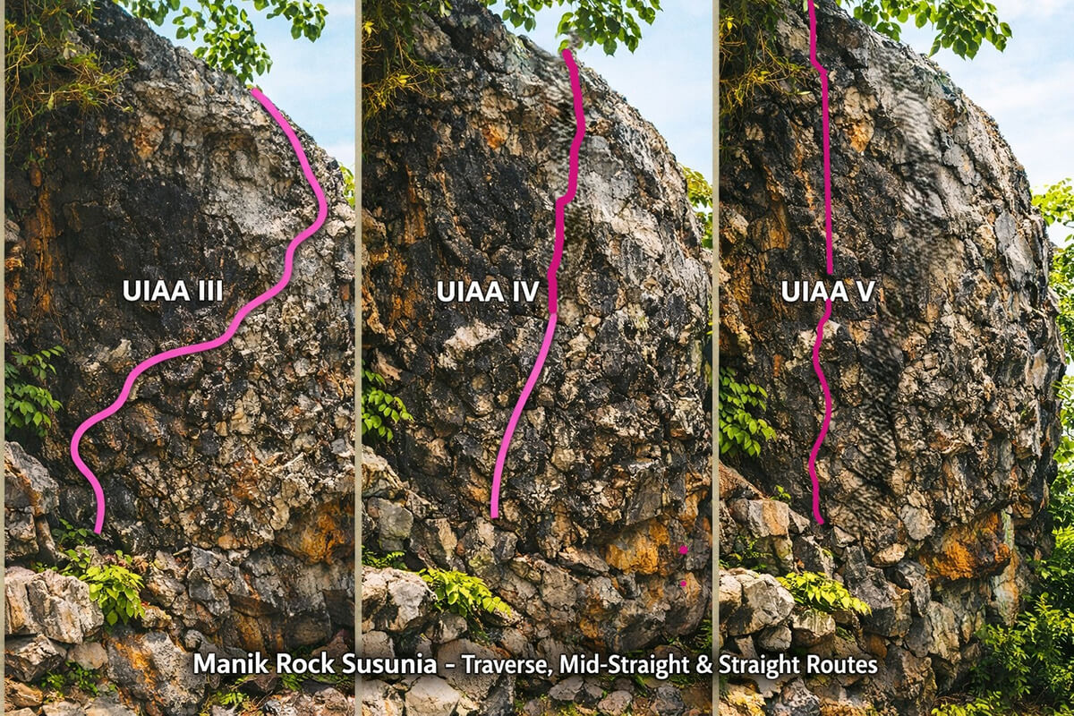
However, one must understand, that difficulties of any climb may vary depending on 1) Rock angle 2) Hold size and distribution 3) Exposure and 4) Movement style, particularly when on-site assessment is being made. Also, as an effect the hardest move in any climb naturally varies. And, as UIAA rating signifies the hardest technical move, grades may differ even if the routes are hardly few feet apart on a particular rock-face. This has been nicely elaborated through the above photo of three routes of three different grades along the same face, here Manik Rock of Susunia, for your easy understanding.
This elaboration now gives you a deep technical and cultural framing of the UIAA scale. Here, I want to elaborate the Grade VII–XII more, since these are the elite levels that generally go beyond what Bengal’s natural granite usually offers. Even though they are few in Purulia or Bankura, understanding them is a requirement, I feel.
UIAA Grades VII-XII - Elite and Expert Levels
Grade VII (UIAA VII)
- Features: Sustained vertical or overhanging climbing with very small holds (tiny edges, shallow pockets).
- Recognition: Climbers must rely on fingertip strength, precise footwork, and advanced rope techniques.
- Experience: This is the threshold where climbing becomes “elite.” Moves are gymnastic, requiring dynamic balance and body tension.
- Context: Available in the outdoors in Bengal, though less, but seen in international sport climbing crags (e.g., Dolomites, Alps).
Grade VIII (UIAA VIII)
- Features: Steep overhangs, roofs, and sequences of tiny crimps or slopes.
- Recognition: Holds are often invisible from below; climbers must memorize sequences.
- Experience: Requires explosive power, endurance, and mental control. Falls are longer, protection placements more demanding.
- Context: Equivalent to advanced sport climbing routes; Bengal granite, though seldom produces such formations, but available at few sites.
Grade IX (UIAA IX)
- Features: Extremely technical, with minimal holds, requiring dynamic moves (leaps, “dead points”).
- Recognition: Routes often look blank; climbers must trust friction and micro‑edges.
- Experience: Only highly trained climbers attempt these; finger strength and core stability are critical.
- Context: Comparable to cutting‑edge sport climbs in Europe; Bengal’s natural faces rarely reach this level, except a few.
Grade X (UIAA X)
- Features: Sustained roofs, overhangs, and sequences of moves that demand gymnastic ability.
- Recognition: Holds are microscopic; protection is sparse.
- Experience: Climbers must combine athleticism with technical mastery; falls are serious.
- Context: International benchmark for elite climbers; Bengal’s granite is not shaped to produce such routes except a few, may be.
Grade XI (UIAA XI)
- Features: Routes at the limit of human ability—tiny crimps, extreme overhangs, and complex sequences.
- Recognition: Requires years of training, specialized sticky shoes, and often indoor preparation.
- Experience: Climbers operate at the edge of endurance and precision; mistakes mean failure.
- Context: Rare even globally; Bengal’s natural terrain does not reach this grade.
Grade XII (UIAA XII)
- Features: The absolute pinnacle—routes that demand extraordinary strength, balance, and creativity.
- Recognition: Holds are almost imperceptible; movements resemble gymnastics on vertical stone.
- Experience: Attempted by only a handful of climbers worldwide; represents the frontier of climbing evolution.
- Context: Bengal’s granite formations are not conducive to such extremes, but knowing this grade situates local climbs within the global scale.
Here’s a comparison chart showing how the three most widely used free climbing grading systems line up against each other:
Climbing Grade Comparison
| UIAA Grade | French Grade | American YDS |
|---|---|---|
| III | 3a | 5.4 |
| IV- | 4a | 5.5 |
| IV | 4b | 5.6 |
| IV+ | 4c | 5.7 |
| V- | 5a | 5.8 |
| V | 5b | 5.9 |
| V+ | 5c | 5.10a |
| VI- | 6a | 5.10b |
| VI | 6b | 5.10c |
| VI+ | 6c | 5.11a |
| VII- | 7a | 5.11d |
| VII | 7b | 5.12b |
| VII+ | 7c | 5.12d |
| VIII- | 8a | 5.13b |
| VIII | 8b | 5.13d |
| VIII+ | 8c | 5.14b |
| XI | 9a | 5.14d |
| XII- | 9b | 5.15b |
| XII+ (Silence) | 9c (Silence) | 5.15d (Silence) |
Please note:
- UIAA: Roman numerals, the scale is widely used in Europe and internationally, used for Alpine and traditional climbing.
- French system: Dominant in Europe, focuses only on technical difficulty, now became a standard for sport climbing.
- YDS (American): Dominant in North America, adds suffixes (PG, R, X) for risk, typically focusing on the hardest move on a route like UIAA.
Example: Silence in Norway (2017) is graded XII+ (UIAA), 9c (French), and 5.15d (YDS), — the hardest confirmed free climb in the world, so far.
As, Bouldering is a subset of rock climbing focused on short, powerful, and highly technical movements on walls/boulders no higher than 6 meters/20 feet, and almost all sites possesses such features, instead of getting into details of procedure for solving bouldering “problems”, I feel it a necessity to provide some glimpse of its gradation. Given below is a bouldering grade comparison chart between the two dominant systems — the French Font scale and the American V‑scale:
Bouldering Grade Comparison
| Font Grade (France) | V-Grade (USA) |
|---|---|
| 3 | VB (Beginner) |
| 4 | V0 |
| 5a | V1 |
| 5b | V2 |
| 5c | V3 |
| 6a | V4 |
| 6b | V5 |
| 6c | V6 |
| 7a | V7 |
| 7b | V8 |
| 7c | V9 |
| 8a | V11 |
| 8b | V13 |
| 8c | V15 |
| 9a (Burden of Dreams) | V17 |
Please note:
- Font scale: Originated in Fontainebleau, France. Uses numbers with A/B/C and + refinements. Purely technical.
- V-scale: Created in the USA (Hueco Tanks). Starts at V0, open-ended. Dominant in NorthAmerica.
- So far, Hardest boulder (2025): Burden of Dreams in Finland — Font 9A / V17.
Rock Faces of Bengal: A Heritage of Climbing and Culture
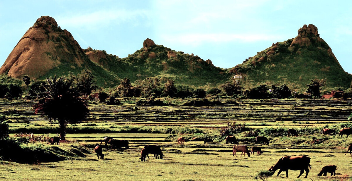
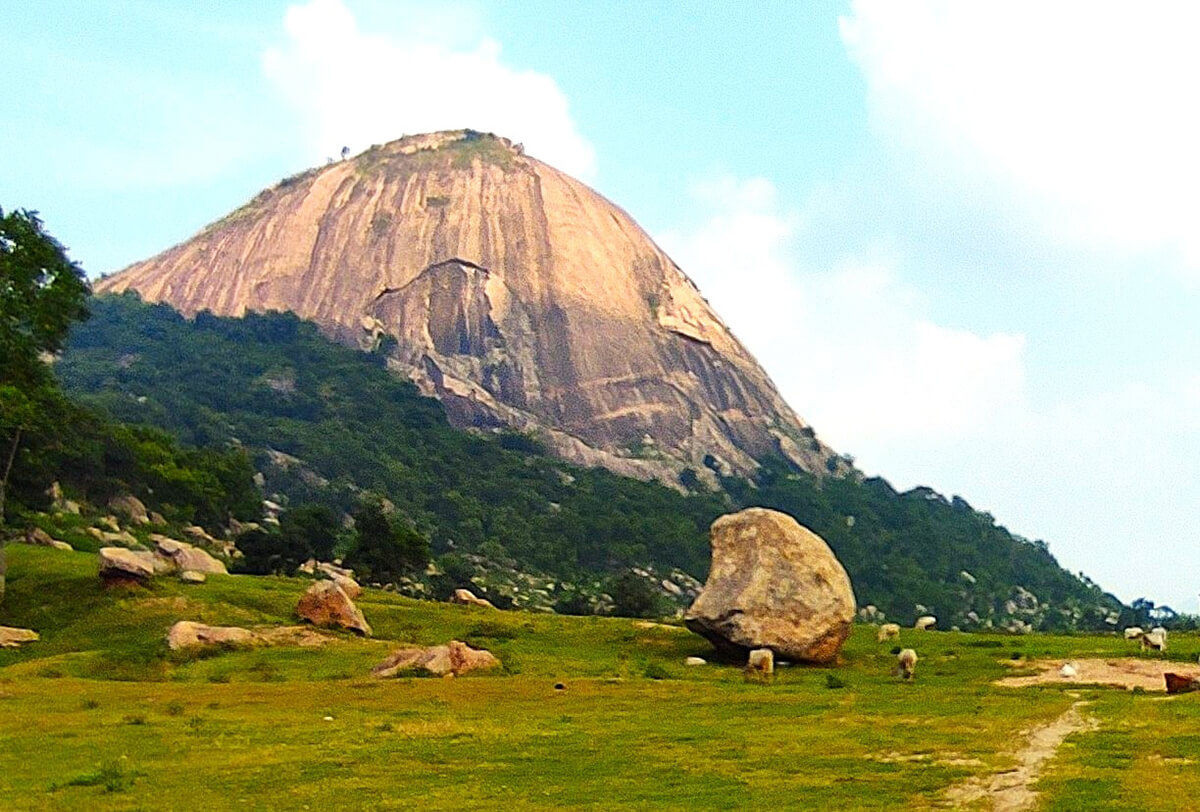
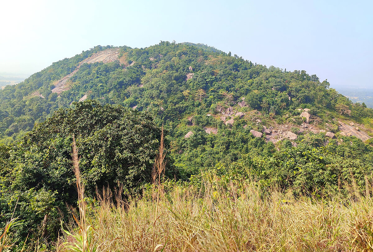
The districts of Bankura and Purulia in West Bengal are home to some of the most storied rock faces in eastern India. Their granite outcrops, domes, and boulder fields have long served as training grounds for generations of Bengali mountaineers. Also, these places stand as cultural landmarks in tribal heartlands. Each site carries its own climbing character, could be expressed through the UIAA grading system, and its own resonance in the collective memory of Bengal’s mountaineering heritage. Truely speaking, Susunia (popularly known as Susunia Pahar) being the birthplace of Rock-climbing in Bengal deserves elaboration for two reasons i) history behind it and ii) it’s type of rock which made it so popular for rock-climbing training.
Susunia Hill (Bankura)
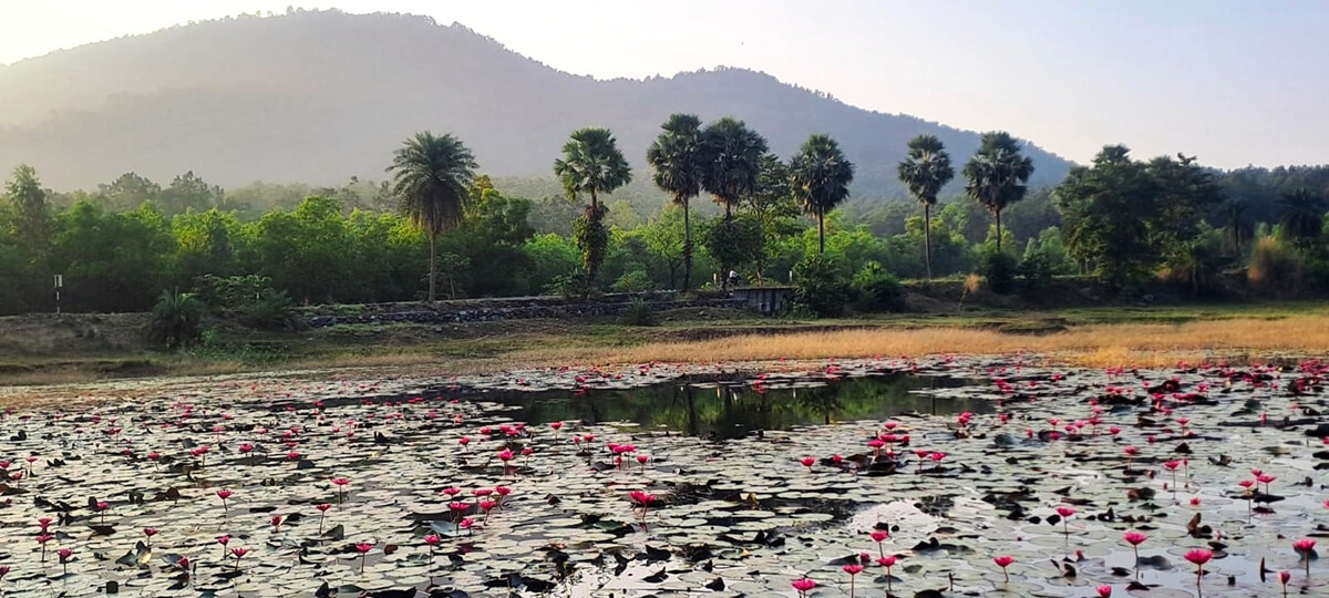
Susunia hill nestles in southern West Bengal, India, accessible via the Bankura-Purulia road turning off at Chhatna. This ancient hill is 10 kilometers North-East of Chhatna and at about 30 kilometres distance from Bankura Junction Railway station. Amidst the spectacular landscape of lavish green of 3.20 sq.km and red soil, Susunia hill owns two tops. The higher one owns an elevation of 447.43 meters / 1,468.02 feet above sea level having coordinates: 23°23’45.30” N / 86°59’04.98” E. Its smaller top is having an elevation of 349.19 meters / 1,145.69 feet above sea level having coordinates: 23°23’47.95” N / 86°58’48.01” E. It is a popular place for its great archaeological value – many mysterious fossils, like ancient fossils of Giraffe, Asiatic Lion, Hyena and many more animal species and stone-age tools, found here. The river, Gandheswari keeps whispering along little away from the hill, while the ‘Palash’ dominates the place with its fiery orange hue in seasons. Guests on wings like Asian Paradise Flycatcher, Indian Pitta and many more can be seen in this place. It’s a home to vibrant butterflies like Golden Angel, Tawny Raja, Spotted Swordtail etc. and this place is a pure bliss in Spring as this natural sanctuary glows like a Diva then.
The hill of Archaean era, is believed to be more ancient than the Himalayas. The crowd of ‘Sal-Palash’ and the soft green light while climbing up the slopes of the hill amazes one. It is also a great reserve of various types of medicinal plants.
An open temple of ‘Narasimha’ in the foothills attracts everyone. The stone idol doesn’t look like another Hindu goddess. The monolith of Narasimha has a demonic look which is completely different from Purana’s description. It seems the aboriginals from this place like Santhals, Kols, Munda, Vils etc used to worship the idol. Near the ‘Narasimha’ temple, spring water is coming out of a stone-spout that has medicinal benefits.
Susunia
The Susunia hill is rich in historical value - rock inscription of 4th century AD is considered to be the ‘oldest’ rock inscription of West Bengal, is an ASI protected site now. According to historical views, Raja Chandravarman built his fort in this place and the rock inscription was kept in the place named Pushkarana. Pushkarana or Pakhanna was the Capital of Chandravarman’s kingdom. People believe that Raja was killed against a battle with Chandra Gupta Maurya. The ancient rock inscription consists of two parts and a prominent ‘Chakra’(wheel) with blazing edges. The first part indicates that the inscription is the work of Raja Chandravarman and the second one states that the village of Choshagrama was transferred to Chakrasvamin. However, location wise the inscription, popularly known as Shilalipi, is located near present Sheulibona village on the north-east of the hill.
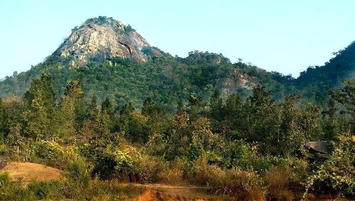
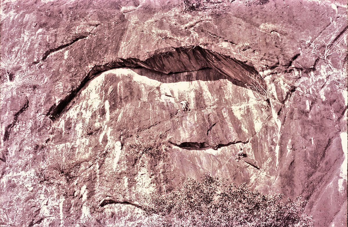
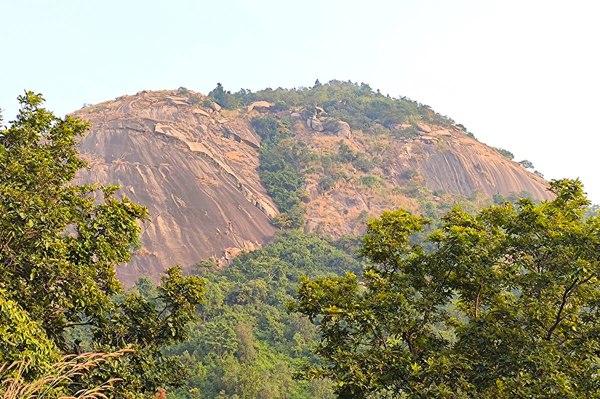
Susunia, a part of the Eastern Ghats and a gradual descent from the Chota Nagpur Plateau, is situated at the north-western part of Bankura District. It is perhaps Bengal’s most famous training site in Rock-climbing. Its metamorphic rock, streaked with quartz veins, provides slabs and vertical practice walls (UIAA III–VIII+). Generations of climbers have honed their craft here, making Susunia synonymous with mountaineering education in Bengal. The site’s heritage inscriptions and sacred associations enrich its identity, blending physical challenge with cultural reverence.
It may be mentioned here that the rock of Susunia hill is geologically different from that of granitic formations of Ayodhya or other nearby hills. It formed from sandstone metamorphosed under high pressure and temperature and is known as quartzite. Being metamorphosed sedimentary rock, it shows visible layers or strata. These rocks are extremely hard and have numerous joints and fractures, making Susunia especially suitable for rock-climbing training.
Susunia Hill (the first training site in Bengal) in brief:
- Famous as a training site since January,1965(organised by Himalayan Association; later JUMHC since Dec, 1966).
- Slabs and crack systems → UIAA III–V+.
- Steeper practice walls (used by mountaineering clubs) → UIAA VI-VII.
- Much steeper and technical climbs (very occasionally done by experts) UIAA VII+ to VIII+.
Now we will discuss about Ajodhya Hills of Purulia district. Interestingly, one will find lots of similarity in almost all the sites of Purulia mainly in the type of rock as they originated from same geological reasons.
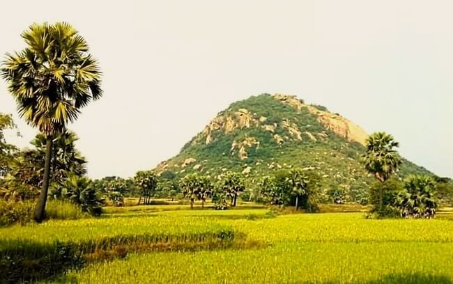
Ajodhya Range, is a small plateau with hilly surroundings located in the Purulia district of the state West Bengal, India. It is the easternmost part of the Chhotanagpur Plateau and extended part of Eastern Ghats range. The highest peak is Chamtuburu (720 m/2,360 ft, Coordinates - 23°17′12″N 86°06′56″E), also the highest peak of southern West Bengal. The nearby populated town is Baghmundi. Geographically, Purulia is situated in the westernmost part of West Bengal and forms the lowest step of the Chota Nagpur Plateau. The district features a rugged and undulating landscape, marked by scattered hills, ridges, and plateaus. The soil is predominantly lateritic, supporting dry deciduous vegetation.
Granite hills generally have an inverted bowl or dome-like shape, broader at base and tapering upwards. Being igneous, granite is hard and compact, producing smooth rock walls. Two types of cracks are visible - the first is exfoliation causing peeling off of the outer layers; the second type is called joints, formed during or after the cooling of granite magma.
The granite here is weathered, brittle in places as granite can flake, yet firm, demanding pinch hold dependant friction climbing and balance. Ajodhya’s sprawling granite landscape offers a spectrum of climbing experiences. Gentle slabs (UIAA III–IV), and scattered boulders (V3 to V9 and above) welcome beginners, while vertical crack systems (UIAA IV–VIII and above) challenge the intermediate, advanced and even the elite climbers. Beyond its technical appeal, Ajodhya is a cultural cradle of tribal communities, where climbing harmonizes with the rhythms of local life.
Major rivers flowing through the region include the Kangsabati, Subarnarekha, and Kumari, which play a crucial role in the district's irrigation and ecology. The Ajodhya Hills, located in the southern part of the district, are part of the extended plateau region and serve as an important ecological and tourist zone.
The climate of Purulia is classified as tropical savanna (Code: Aw) under the Köppen climate classification. Summers are hot and dry, while winters are cool and pleasant. Rainfall occurs mainly during the monsoon months from June to September ranging between 1100 to 1500 mm in average. Though Purulia is generally known as the warmest and driest district in West Bengal with a prolonged dry season and lower average annual rainfall, the district is known for its scenic beauty, tribal villages, and potential for eco-tourism development. The main hills which are noted for rock-climbing interest, namely, Mathaburu, Pakhipahar, Gorgaburu, Gajaburu etc. are within Ajodhya hills range and hence possess similar type of rocks. Others like Joychandi, Bero, Tilaboni, Bansa hills, though geographically out of Ajodhya hills ecosystem, possess almost similar type of rocks. Here, I will discuss each of them in brief.
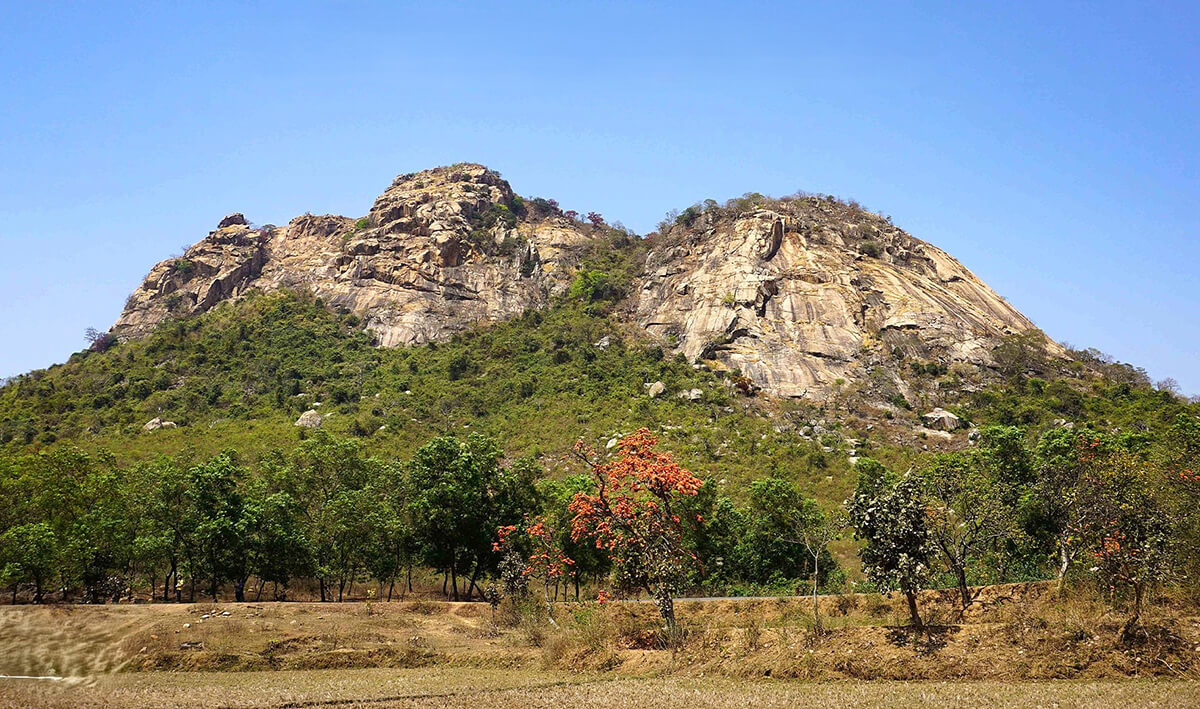
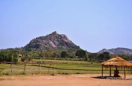
Mathaburu (near Balarampur within Mathaburu Forest Range, under Baghmundi Police Station):
--- Please note: the rail station at Balarampur is known as Barabhum.
On the Balarampur–Baghmundi road, at about 16 kilometres from Balarampur lies the Mathaburu Forest Range Office (FRO) on the right. Just behind the FRO, Mathaburu (elevation: 501.48 meters / 1,645 feet above sea level; coordinates: 23°07’34.94” N / 86°04’32.49” E), rises as a massive, dome-like, vertical granite outcrop with crack systems, smooth slabs and ledges inviting climbers. Being surrounded by dense greeneries, it is scenically beautiful as well. A forest rest house within the FRO campus and other nearby attractions, such as a Kali-temple on top of Mathaburu and other peaks like Muraburu (later known as Pakhipahar) along with their surrounding tops enhance its appeal as part of a broader ecotourism circuit in the area. In fact, Mathaburu Forest Range (FR) covers a respectable area of about 153 square kilometres having presence of diverse flora and fauna including Elephants. There is a bolder zone at the base level and climbers of different levels encounter UIAA III–VIII routes, where exposure and balance are constant companions. The moderate exposure of ample climbing routes makes them suitable for club training. There, in the FRO campus, also exists a hut named ‘Pradip Das memorial Hut’ built, in the first half of 1980s, for the use of adventure enthusiasts and nature lovers. The dome’s commanding presence makes it both a physical challenge, often offering Grade VII+ and above category climbs and a cultural beacon, celebrated in local lore as a guardian of the hills.
Mathaburu
A grade UIAA VII+ climb at Mathaburu being led by the writer.
In brief, Mathaburu is:
- Famous as a training site since January,1980 (first Rock Climbing Training course was jointly organised by KF, CMA and Bharat Scouts; JUMHC since 1981).
- Having gentle slabs and boulders → UIAA III–IV and V3 to V7.
- Vertical granite faces with cracks → UIAA IV–VI.
- Steeper walls of variety → UIAA VI+ – VII +.
- Much steeper and technical climbs available (very occasionally may be done by experts) UIAA VIII+ and above.
Pakhipahar (within Mathaburu FR, under Baghmundi PS), Purulia:
On the same Balarampur–Baghmundi road, about 14 kilometers from Balarampur near the village of Srirampur, lies Bhuchungdih More (a junction)—just two kilometers before Mathaburu. To the right stands Muraburu (elevation: 525.30 meters / 1,723.51 feet above sea level; coordinates: 23°07’10.33” N / 86°06’12.66” E). Thanks to the monumental creations of sculptor Shri Chitta De and his team—over sixty rock‑cut bird figures adorning the southeastern slope—the site now commands attention from a far and has earned the name Pakhipahar (“Bird Hill”).
Pakhipahar
In brief, Pakhipahar is:
- A domain for advanced climbers.
- Compact granite walls, steep faces, overhangs, and technical crack sequences adore it.
- Generally, UIAA grade III–VII routes, with existence of higher grades of course.
- Rope protection and endurance are essential.
For Bengal’s climbing clubs, it once served as a testing ground for skill and discipline; and were tested against unforgiving stone, though used less frequently for various reasons now.
Gorgaburu (within Mathaburu FR, under Baghmundi PS), Purulia:
Gorgaburu is accessible primarily by the same Balarampur–Baghmundi road. One has to get down from the bus at about 11-kilometre point, from Balarampur, from where local transportation such as jeeps or auto-rickshaws could be arranged for the final leg to the base. It is the second highest top of Ajodhya Hills (elevation: 677 meters / 2,221 feet above sea level; coordinates: 23°08’37.30” N / 86°07’42.80” E), rises as a massive, dome-like, granite outcrops with crack systems, smooth slabs and ledges in dense greeneries, inviting types of climbing. The surrounding region supports diverse flora and fauna, with tropical dry deciduous forests featuring trees like sal, piyal, palash, and mahua, and serves as a habitat for various bird species, particularly during monsoon and winter seasons. Now-a-days, it also includes facilities like a Forest Rest House, making it a favoured destination for adventure enthusiasts and nature lovers. Nearby attractions, such as the Pardi Dam and other peaks like Mayuri, enhance its appeal as part of a broader ecotourism circuit in the area. Climbers encounter UIAA III–VII routes, where exposure and balance are constant companions.
Gorgaburu
In brief, Gorgaburu is:
- Being used as a training site in recent years.
- Gentle slabs and boulders → UIAA III–IV and V3-V6.
- Vertical granite faces with cracks → UIAA IV–V.
- Steeper walls of variety → UIAA V–VII.
- Much steeper and technical climbs (occasionally could be done by experts) UIAA VII+ and above.
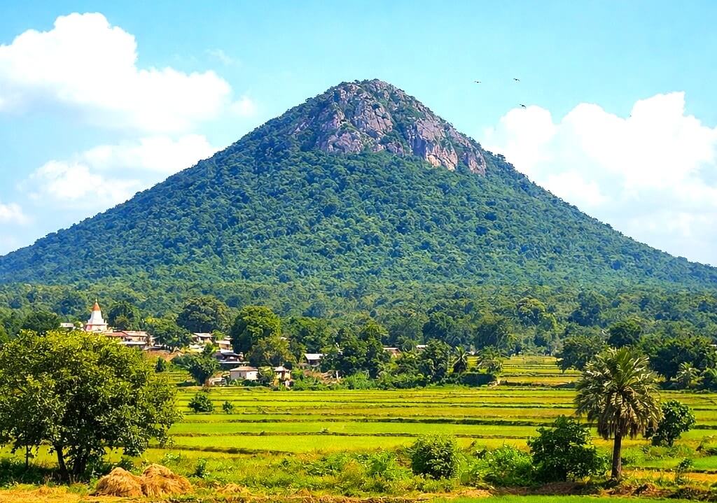
Gajaburu (near Kantadi under Kantadi RO & Arsha PS):
Gajaburu is a serene, rugged hill located in the Ajodhya Hills ecosystem and accessible from both Tamna and Kantadih railway stations of Purulia-Chandil section; having elevation: 550.22 meters / 1,805.27 feet above sea level; coordinates: 23°14’55.06” N / 86°13’22.41” E, rises as a massive, dome-like, vertical granite outcrop with crack systems, smooth slabs and ledges inviting different levels of climbers. Climbers encounter UIAA III–VII routes, where exposure and balance are constant companions.
Gajaburu
In brief, Gajaburu is:
- Famous as a training site since early,1980 (organised by CC).
- Gentle slabs and boulders → UIAA III–IV and V3 to V7.
- Vertical granite faces with cracks → UIAA IV–V.
- Steeper walls of variety → UIAA V–VI.
- Much steeper, technical and exposed climbs (very occasionally done by experts) UIAA VII+ and above.
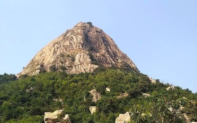
Joychandi Hills (Raghunathpur, Purulia):
Joychandi Hills, popularly known as Joychandi Pahar, are a cluster of seven scattered, rocky hills located at 23°30’59.00” N / 86°40’49.22” E in the Purulia district of West Bengal, about 2 km south of the town of Raghunathpur. These seven scattered, rocky hills, are having local names and legends. They are named as Jigadhala, Kali, Joychandi, Eksira, Sewli, Nera and Sita pahar, in descending order of their heights. The closest major railhead is Adra Junction, with the nearby Joychandi Pahar Railway Station connecting the site to Asansol and Adra. The average elevation of the entire region above sea level is approximately 155 meters (about 509 feet) and the primary hills rise to an elevation of approximately 80 to 600 feet above the surrounding plains. They are easily reachable by road from Purulia town (approx. 25 km away) as well. The historical Garpanchakot is located just 21 km away from it.
Joychandi’s rounded granite domes are historic in Bengal’s climbing tradition. Their pinch-holded friction slabs (UIAA III–VII) have trained countless beginners, offering accessible routes that emphasize balance and technique over strength. The site is not only a climbing ground but also a cultural landmark, immortalized in Bengali cinema and literature, symbolizing resilience and aspiration.
Joychandi Pahar
However, regarding formation history, Geological surveys and modern scientific studies confirm that the Joychandi pahar range, having Palaeoproterozoic Gangpur Granite of Precambrian era as bedrock, has no volcanic origins and is not an extinct or dormant volcano - as it was thought of and persistent local myths still exist. The hills are the result of continental uplift and tectonic forces that formed the Chota Nagpur plateau. The hills sit on the lowest step of the plateau. Distinctive dome-shaped landforms and boulder-strewn terrains were created by millions of years of physical weathering and “onion-skin” exfoliation. The tops and steep slopes of the granite outcrops are covered by lateritic caps resulting from seasonal weathering. The site is officially recognised by geologists as a very valuable one and a core part of the Singhbhum Protocontinent Research Gate.
A grade UIAA VII+ climb at Joychandi Pahar led by the writer(1979); others in the team were Amitava Dutta and Amit Chowdhury. Here in the photo Shri Chowdhury is visible while removing a left over piton. It was basically a pinch hold dependant friction climb on a slightly overhanging wall. Route was named Layton Kor-I.
In brief, Joychandi is:
- Historic training ground for climbers since Dec,1966 (by JUMHC, later by MLA since Jan,1970 and others).
- Large granite domes with friction climbing → UIAA III–IV.
- Vertical faces with cracks and ledges → UIAA IV–V.
- Steeper walls of variety → UIAA V–VII.
- Much steeper and technical climbs (very occasionally done by experts) UIAA VII+ and above.
Beropahar (near Asansol under Raghunathpur PS):
Beropahar is reachable from Bero Railway station (3 kilometres) having elevation: 303.96 meters / 997.29 feet above sea level; coordinates: 23°32’20.91” N / 86°45’36.78” E, rises as a comparatively small hillock with granite outcrops having crack systems, smooth slabs and ledges inviting rock-climbing enthusiasts. Climbers encounter UIAA III–VI routes, where marginal exposure and balance are constant companions. It is Khelaichandi hill just beside main Bero hill where rock-climbing training started initially because of availability of good climbable rock faces. Joychandi hills at 6 kilometres apart and historic Garhpanchakot at 11 kilometres are nearby places of interest from Bero hills to note.
Beropahar
In brief, Beropahar is:
- Known as a training site since 1980s (initially camp organised by MLA, later by various Durgapur-Asansol based clubs).
- Gentle slabs and boulders → UIAA III–IV and V3 to V6.
- Vertical granite faces with cracks → UIAA IV–V.
- Steeper walls of variety → UIAA V–VI and above.
Tilaboni (near Anara under Raghunathpur Sub-Division):
Tilaboni is accessible primarily from Anara, a junction railway station only 14 kilometres from Adra Junction on the South Eastern Railway in Purulia district, West Bengal. Local transportation such as auto-rickshaws can be arranged for the final leg of about another 14 kilometres to the quiet, peaceful base of the hill surrounded by greeneries along with many palm trees unlike other Rock-site bases of Purulia hills. With red soil and a rugged topography, the base area is surrounded by striking rocky outcrops and many boulders, making it a well-known destination for climbers, especially bouldering enthusiasts.
Tilaboni (elevation: 403.48 meters / 1,323.82 feet above sea level; coordinates: 23°25’01.15” N / 86°33’05.98” E), rises as a massive, blunted-dome-like, granite outcrop with crack systems, smooth slabs and ledges inviting various levels of climbing including bouldering and friction climbing. Climbers encounter UIAA III–VII routes, where exposure and balance are constant companions. Till early 2026, five numbers of ‘Bengal Boulder Festivals’ have been organised at Tilaboni which started since December, 2021. So far, the highest grade of boulder problem successfully topped by the elite competitors reached 7A+ to 7C as per Fontainebleau scale, equivalent to V7 to V9 on the Hueco scale.
Tilaboni
In brief, Tilaboni is:
- Famous as a training site since late 2010s.
- Gentle slabs and boulders → UIAA III–IV, and V3 to V9 and above.
- Vertical granite faces with cracks → UIAA IV–V.
- Steeper walls of variety → UIAA V–VI.
- Much steeper and technical climbs are available UIAA VII and above.
Bansa hills region (near Tulin, Purulia)
Bansa is a picturesque hilly site near Tulin, beside the Ranchi–Purulia Road. The nearest railway stations are Tulin, Jhalda and Muri Junction (Jharkhand). The region is quite extensive, enriched with scattered hills bearing different names and climbing characteristics. Among them, the tallest granite dome-shaped hill is Bansa hill itself, popularly known as Bansapahar. There is a temple of Devi Bansa at its foothill just adjacent to Ranchi–Purulia Road opposite ‘Bansa More’, the entry point to Bansa village. From Bansa More, the main face of Bansapahar could be reached in a five minutes’ walk. On the opposite side (of the main road), located near Bansa village at the closest vicinity of Dhelburu, Ranitungri, Majhertungri and Chandni Pahar, about a kilometre away from the entry point and just 9.40 kilometres from Muri Railway Junction (Jharkhand), 7.20 kilometres from Jhalda Railway station, and 4.30 kilometres from Tulin Railway station, an established campsite named as ‘Juno’s Camp’ provides both accessibility and proximity to the climbing sites at Dhelburu, Ranitungri, Majhertungri and Chandni Pahar cluster, established by JUMHC in 2025-26(regular Rock-climbing training course organised since Feb, 2026). Another at the Karilata campsite, hardly 1.50 kilometre from village entry point and about 15 minutes’ walk from the Juno’s campsite, there exists Majherpahar to the west of Rishitungri, which is also an established training site (established by JUMHC in 2024).
So, the Bansa hills area is a constellation of climbing sites, each with its own character:
Bansapahar (main outcrop): With an elevation: 539.30 meters / 1,769.44 feet above sea level; coordinates: 23°22’00.69” N / 85°55’35.34” E, Bansa rises as a massive, dome-like, vertical granite outcrop with crack systems, smooth slabs and ledges inviting types of climbing including pinch hold dependant friction climbing. Here, rock climbing training started since Jan, 2000 by NOVA (The Nature Oriented Venturous Association) under the stewardship of Shri Partha Sarathi Dutta. Climbers encounter types of climbs along UIAA III–VII routes. Starting from few boulders, small slabs/walls to long granite walls (UIAA V–VI), emphasizing friction climbing and stamina are accessible for training, with a nearby campsite providing easy access to the climbers. Its scenic setting adds cultural charm. Boulder hub (V3 to V5) with easy traverses (UIAA II–III), ideal for beginners and warm ups, granite massifs offering mixed slab/wall and crack climbing (UIAA IV–V), steeper granite walls (UIAA V–VII), demanding technical climbing and endurance from advanced climbers...all serves as a community training ground, central to local climbing culture.
Bansapahar
In brief, Bansapahar is:
- Used as training ground for climbers since Jan, 2000 (by NOVA, others later).
- Gentle slabs and boulders → UIAA II–III, and V3 to V5 for beginners.
- Vertical granite faces with cracks → UIAA IV–V.
- Steeper walls of variety → UIAA V–VII+ and above.--- all provide very good climbing ambience at Bansa hill main outcrop.
Dhelburu: With an elevation of 496.62 meters / 1,629.41 feet above sea level and coordinates: 23°22’52.18” N / 85°55’53.42” E, it rises as a massive, attached double dome-like, vertical granite outcrop with crack systems, smooth slabs/walls and ledges inviting various levels of climbing. Climbers encounter boulder hubs (V3 to V9 and above) at the lower level, small walls (UIAA III–IV), steeper climbs with UIAA V–VIII routes, demanding technical crack climbing where exposure, balance, stamina and endurance will be under constant observation once accessed for training, with the adjacent Juno’s campsite providing a community hub for climbers.
Dhelburu
In brief, Dhelburu is:
- Used as training ground for climbers since 2000s (by NOVA for bouldering etc., others later).
- Gentle slabs and boulders → UIAA II–III, and V3 to V5 for beginners (and up to V9 and above for experts).
- Vertical granite faces with cracks → UIAA IV–V.
- Steeper walls of variety → UIAA V–VIII and above. --- all provide very good climbing ambience at Dhelburu main outcrop.
Ranitungri: With vertical granite slabs and walls having moderate cracks (UIAA III–IV), requiring balance and rope protection, very suitable as a training site at the basic level of training. With the Juno’s campsite, hardly 5 minutes’ walk away, trainees enjoy a sense of enjoyable community hub for them.
Ranitungri slopes with Bansapahar at the background.
In short, Ranitungri is:
- Used as training ground for beginners since 2025-26(by JUMHC, others later)
- Granite slabs having moderate cracks→ UIAA II–III
- Some sharper granite walls → UIAA III–IV
Majhertungri: Majhertungri rises as a near vertical granite outcrop with crack systems, smooth slabs and ledges. Climbers encounter UIAA III–IV routes, boulder clusters (V3 to V6) and small walls (UIAA IV–V), accessible for initial training, with the Juno’s campsite, hardly 7/8minutes walk away.
Majhertungri slopes with Ranitungri and Dhelburu tops at the background.
In short, Majhertungri is:
- Used as training ground for beginners since 2025-26(by JUMHC, others later)
- Boulder fields and traverses → V3 to V6 and UIAA III–IV
- Some sharper granite walls → UIAA IV–V
Chandnipahar: Chandnipahar (elevation: 478.04 meters / 1,568.45 feet above sea level; coordinates: 23°22’58.25” N / 85°56’09.89” E), rises as a massive, vertical granite outcrop with crack systems, smooth slabs, walls and ledges on its top inviting technical, as well as friction climbing. At a rope length of about 160 feet across an average 60–70degree slab from the wall’s base, one reaches to the climbing site situated on top. Climbers encounter slabs and walls (UIAA III–V), steeper smooth granite walls and overhangs (UIAA VI–VIII and higher), where exposure, endurance, stamina and balance have to be constant companions. Also, its scenic setting adds additional charm to anyone, full to the brim.

Chandnipahar
In brief, Chandnipahar is:
- Used as practicing ground for its trained climbers since Dec, 2025 (by JUMHC).
- Gentle slabs with high exposure → UIAA III–IV.
- Vertical granite faces with cracks → UIAA V–VI.
- Steeper walls of variety → UIAA VI–VIII and above.--- all provide very good climbing ambience at Chandni Pahar main outcrop.
Majherpahar (beside Karilata campsite area): Majherpahar (elevation: 408.03 meters / 1,338.75 feet above sea level; coordinates: 23°23’06.15” N / 85°55’33.80” E), rises as a big, barrel-like, granite outcrop with crack systems, smooth slabs, walls and ledges and a boulder hub inviting various modes of climbing. Interestingly, main climbing zones are shrouded by dense greeneries and hence remain hidden. Climbers encounter UIAA III–VI routes, where exposure and balance are constant companions. Boulder clusters (V3 to V6) and small walls (UIAA III–IV), accessible for training, with the very nearby campsite at Karilata providing a beautiful hub for participants beside a natural waterbody.
Majherpahar
In short, Majherpahar is:
- Used as training ground for climbers since Dec,2024(by JUMHC for KPPS, others later)
- Boulder fields and traverses → V3 to V6 and UIAA II–III
- Some sharper granite walls → UIAA IV–V
- Steeper walls of variety → UIAA V–VI
- Much steeper technical climbs available, though very few (may very occasionally be attempted by experts) UIAA VI+ and above
Together, these sites form a mosaic of climbing opportunities, from beginner to advanced, and embody the community spirit of Bengal’s mountaineering heritage. However, I do reiterate again that - Bankura is known for mainly Susunia hill, while Purulia is known for Joychandi, Mathaburu, Gorgaburu, Pakhipahar, Gajaburu, Tilabani, Beropahar and hills of Bansa range, where granite outcrops provide natural climbing terrain. Besides, in recent years a number of other sites are being used by various clubs, mainly to get rid of financial burden imposed by Forest Department of West Bengal, crowd and hence for not getting the intended site of choice as per suitable time-slot of the organisers, proximity and other reasons/restrictions. They are: Burababa, Dholburu of Purulia, Mama-Bhagne (Birbhum), Ratopani (Jalpaiguri), etc., even at Jayanti and Buxaduar (Alipurduar) – though they are not popular because of various reasons including type and availability of proper rocks for an extensive Rock-climbing training course.
Here’s a comparative table mapping the major rock-climbing sites of Bankura and Purulia, their approximate UIAA grades and typical climbing styles. This should serve as a practical reference for heritage documentation and training analysis. But be aware that, it is most likely that the higher end of ‘Grades of climbs’ presently available in each site will get enhanced depending on better climbing techniques & style, better quality of climbing equipment, higher capability of our next generations of climbers etc, with the passage of time. By then, it is most likely that our future generation of climbers will be opening more & more new routes, which today’s generation might apparently feel impossible to climb!
Comparative Table of Bengal Rock Sites
| Site | Approx. UIAA Grade Range | Typical Climbing Style / Features | Remarks |
|---|---|---|---|
| Susunia (Bankura) | III-VIII+ | Famous training site since the onset of rock climbing in West Bengal; slabs, cracks, vertical practice walls and even overhang available; no boulder hub as such. | Training started here since January,1965 by Himalayan Association; later by JUMHC since Dec, 1966. |
| Mathaburu (Purulia) | III-VIII+ | Famous training site with boulder hub, vertical granite faces, cracks and ledges, moderate to high exposure, slabby granite: a good site for technical and friction climbing with good infrastructure. | Famous as a Training site since January,1980 (jointly organised by KF, CMA and Bharat Scouts); later by JUMHC since 1981. |
| Pakhipahar (Purulia) | III-VII+ | Steep walls, overhangs, technical crack climbings available. | Previously used as a practicing site by some advanced climbers; yet not very popular as a regular training site because of various restrictions. |
| Gorgaburu (Purulia) | III-VII+ | A hill of granite rocks having dense greeneries, suitable for climbing of beginner to higher level trainees. | Previously used as a practicing site by some advanced climbers; yet not very popular as a regular training site because of various restrictions. |
| Gajaburu (Purulia) | III-VII+ | A dome-like vertical granite outcrop, having much potential for technical and friction climbing and being used as a training ground for beginner to higher level trainees. Boulder hub available. | Famous as a Training site since 1980s (organised by CC); later by various other clubs. |
| Joychandi (Purulia) | III-VII+ | A cluster of dome shaped granite formations having much potential for technical and friction climbing and being used as a training ground for beginner to higher level trainees. Boulder hub available. | Training ground for climbers since Dec,1966 (by JUMHC, later by MLA since 1970 and others). |
| Tilaboni (Purulia) | III-VII | Boulder fields at lower zone, easy traverses, beginner-friendly; possesses some higher-grade climbs at mid-zone. | Training ground for climbers since 2010s, though was a good practicing site by some since long back. Till early 2026, five numbers of 'Bengal Boulder Festivals' have been organised at Tilaboni which started since December, 2021. |
| Beropahar (Purulia) | III-VI+ | A hillock of granite rocks, suitable for climbing by beginner to higher level trainees. | Being used as training ground by various Durgapur-Asansol based clubs since 1980s. |
| Bansapahar (Purulia) | III-VII+ | A dome-like vertical granite outcrop, having much potential for technical and friction climbing and being used as a training ground for beginner to higher level trainees. Few Boulders available. | Training ground at Boulder fields, slabs and moderate walls since Jan, 2000 (by NOVA). |
| Dhelburu (Bansa region, Purulia) | III-VIII | Boulder fields, easy traverses, beginner-friendly lower zone; but possesses some severe grade climbs at upper zone. | Training ground at boulder fields and moderate climbs by few clubs since last couple of years; steeper walls in the upper zone are for higher level climbers - JUMHC explored since 2025 and started Rock Climbing Course since Feb, 2026. |
| Ranitungri (Bansa region, Purulia) | III-IV | Vertical granite slabs and walls, moderate cracks, balance climbing; beginner-friendly training site. | Training ground for climbers since Feb, 2026 (by JUMHC). |
| Majhertungri (Bansa region, Purulia) | III-V | Boulder zone, steeper walls, technical crack climbing, requiring rope protection; a beginner-friendly training site. | The site was explored since 2025 and used as a training ground for climbers since Feb, 2026 (by JUMHC). |
| Chandnipahar (Bansa region, Purulia) | III-VIII+ | Slabs with friction climbing, exposed faces from difficult to severe grades, having great potential for higher level climbers; skill, stamina and endurance required. | So far untouched pristine rock faces; The site was explored since 2025 and initiated as a training site for climbers since Feb, 2026 (By JUMHC). |
| Majherpahar (Bansa region, Purulia) | III-VI+ | Boulder zone, steeper slabs and walls, under dense greenery coverings; Beginner friendly training site beside a make-shift campsite at a picturesque place named Karilata. | Training ground for climbers since Dec, 2024 (explored and course conducted by JUMHC for KPPS). |
Observations
In Bankura, and Purulia, most natural granite formations fall between UIAA III and VII, except a few; and we may perceive them as follows:
- Beginner terrain (UIAA II–IV): Found at all the sites discussed here-in-above in the hilly slopes of both Bankura and Purulia districts of West Bengal.
- Intermediate terrain (UIAA IV-V): Findings are similar as described above except Ranitungri, Majhertungri slabs/walls where UIAA V grade climbs are just few.
- Advanced terrain (UIAA V–VI): Available at all the sites discussed here except Ranitungri, and Majhertungri again. In fact, steeper granite faces requiring high level of technical climbing are available in plenty; which necessitate more exploration by sincere advanced lot of climbers of present and forthcoming generations.
- Rare elite terrain (>VI): Though, Bengal granite seldom produces extreme overhangs or roofs, but isolated sections at almost all sites may approach VII and above level of grades. We need to look out for them, plan climbing on them and possibilities are infinite.
Thus, Bengal’s climbing heritage is characterized by accessible training grounds for beginners, intermediates, and advanced with select advanced sites that challenge even seasoned climbers.
The UIAA grades, when mapped onto Bengal’s granite, do more than measuring difficulty. They tell the story of generations of climbers who learned discipline on Susunia’s walls, balance on Joychandi’s domes, and courage on Mathaburu, Pakhipahar, Gajaburu or Chandnipahar’s steep walls. Each grade is not just a technical marker—it is a cultural milestone, linking Bengal’s mountaineering tradition to the global climbing community.
Related Articles


Place your ad here. Call +919163231788 or Contact Us


